Aeroclub Bladel — VOLMET

NL EN Reload page

Outdoor light: Day Sunrise: 07:20 Sunset: 17:26

Last update done Sunday 25 October 2026 @ 09:05h

Aeroclub Bladel field
09:00–10:00
10:00–11:00
11:00–12:00

Arrow: Wind consensus direction into field centre. Shaded sector: wind model spread (wind from).

Daylight next 24h — hourly outlook

Daylight hours over the next 24 hours (local): rain %, sustained wind Bft, gust Bft, °C.

R%
5 %
10 %
29 %
47 %
61 %
64 %
60 %
55 %
44 %
1 %
1 %
1 %
W
4
5
5
5
5
5
5
5
4
3
3
3
G
6
6
6
6
6
6
6
6
6
4
4
4
T
11.3 °C
12 °C
12.3 °C
12.5 °C
12.2 °C
11.8 °C
11.4 °C
11 °C
10.2 °C
7.4 °C
8.5 °C
9.6 °C

Wind per class — next 3h

Foampies / small scale
No-go
Medium scale nitro/gas/electric
No-go
Large scale nitro/gas/electric
Marginal
RC gliders · thermals
Bad

Window mean: Bft 5 Fresh breeze · 8.7 m/s · Bft 6 Strong breeze · 12.7 m/s · max |cross| Bft 5 Fresh breeze · 9.1 m/s

WIND
Bft 4 Moderate breeze · 7.6 m/s

From 241° · Sun 25 Oct 2026 09:00 · model direction spread 27°

GUSTS
Bft 6 Strong breeze · 11.1 m/s · Δ +3.5 m/s gust factor
GLIDER THERMALS
Weak or unlikely thermals

T − Td: 4.8 °C

Est. cumulus cloud base ≈ 600 m

Rule-of-thumb from temp, dew, cloud and wind vs glider limits — not a dedicated soaring forecast.

Rain chance
5 %
Cloud cover
20 %
Temperature
11.3 °C
Dew point
6.5 °C
Humidity
71 %
Mist / fog

Mist unlikely

Indicative from the same model blend as wind; check at the field.

Observed now — Eindhoven Air Base (EHEH)

Live METAR observation ~13 km NE of the field (same CTR) — a close proxy, but not at Bladel itself.

METAR issued Sun 25 Oct 2026 08:55 · 57 min ago

Wind
Bft 4 · 5.7 m/s · from 230°
matches forecast
Gusts
Bft 5 · 9.5 m/s (KNMI)
Temp.
11 °C
Dew point
8 °C
Humidity
82 %
Cloud base
no significant cloud (METAR)
Sky
Vrijwel onbewolkt (zonnig/helder)
Visibility
9.7 km (good)
Lightning
none reported (METAR)

EHEH METAR: METAR EHEH 250755Z AUTO 23011KT 190V270 9999 NCD 11/08 Q0995 BLU BECMG 24015G28KT

Source: EHEH METAR (NOAA Aviation Weather) for wind, temperature, visibility, cloud base & thunderstorms when recent; Buienradar / KNMI for gusts when METAR has no measured G## and for other fields when available. Cloud base falls back to a T−Td estimate (≈125 m per °C) when no recent METAR.

Flying outlook — next 48 hours

Heuristic from the hourly blend covering the next ~48 hours from now — the last card stops at the current clock time two days out. The day badge and summary focus on 12:00–18:00 local (typical field hours), merged from the 12–15 and 15–18 blocks; the slot list below still covers all daylight. Rain first, then wind (sustained + gust Beaufort averaged, with hard limits for gale conditions), then temperature, then fog. Peak gust speeds are always shown in the facts.

SUNDAY 25 Oct 2026

Unsafe — strong steady wind
CHILLY

Sustained wind from Beaufort 5 upwards in this window.

Day prognosis (badge + summary) is weighted for 12:00–18:00 local — your main flying window. Blocks below show the full daylight picture.

  • Rain chance 12–18 h (max. in window): 64%
  • Wind 12–18 h (peak): Bft 6 — 9.3 m/s sustained, gusts to 13.4 m/s
  • Temperature 12–18 h: 10.2–12.5 °C
  • Fog / mist (model hint): Mist unlikely

Sun ↑ 07:20 · Sun ↓ 17:26 (local)

All daylight flying windows (~3 h each)

  • 09:52–12:00 Unsafe — strong steady wind
    CHILLY WIND: Bft 5 (8.6 m/s) GUSTS: Bft 6 (12.5 m/s) Wind or gusts
  • 12:00–15:00 Unsafe — strong steady wind
    CHILLY WIND: Bft 5 (9.3 m/s) GUSTS: Bft 6 (13.4 m/s) Wind or gusts
  • 15:00–17:26 Unsafe — strong steady wind
    CHILLY WIND: Bft 5 (8.6 m/s) GUSTS: Bft 6 (12.4 m/s) Wind or gusts

Main limiter: wind strength or gusts.

MONDAY 26 Oct 2026

Challenging
CHILLY

Lighter foamies get tossed (moderate breeze).

Day prognosis (badge + summary) is weighted for 12:00–18:00 local — your main flying window. Blocks below show the full daylight picture.

  • Rain chance 12–18 h (max. in window): 51%
  • Wind 12–18 h (peak): Bft 5 — 5.9 m/s sustained, gusts to 8.5 m/s
  • Temperature 12–18 h: 10.4–12.3 °C
  • Fog / mist (model hint): Low mist risk

Sun ↑ 07:22 · Sun ↓ 17:24 (local)

All daylight flying windows (~3 h each)

  • 07:22–09:00 Fair
    COLD WIND: Bft 3 (4.9 m/s) GUSTS: Bft 4 (7 m/s) Wind or gusts
  • 09:00–12:00 Fair
    CHILLY WIND: Bft 3 (5.1 m/s) GUSTS: Bft 4 (7.3 m/s) Wind or gusts
  • 12:00–15:00 Challenging
    CHILLY WIND: Bft 4 (5.6 m/s) GUSTS: Bft 4 (7.8 m/s) Wind or gusts
  • 15:00–17:24 Challenging
    CHILLY WIND: Bft 4 (5.9 m/s) GUSTS: Bft 5 (8.5 m/s) Wind or gusts

Main limiter: wind strength or gusts.

TUESDAY 27 Oct 2026

Challenging
CHILLY

Lighter foamies get tossed (moderate breeze).

Day prognosis covers the rest of today still inside the 48 h window (12–18 h is no longer in this data batch). Blocks below show each remaining slice.

  • Rain chance (rest of day in 48 h): 1%
  • Wind (rest of day in 48 h, peak): Bft 5 — 5.9 m/s sustained, gusts to 8.7 m/s
  • Temperature (rest of day in 48 h): 13.2–13.9 °C
  • Fog / mist (model hint): Some mist risk

Sun ↑ 07:23 · Sun ↓ 17:22 (local)

All daylight flying windows (~3 h each)

  • 07:23–09:00 Challenging
    CHILLY WIND: Bft 4 (5.9 m/s) GUSTS: Bft 5 (8.6 m/s) Wind or gusts
  • 09:00–09:52 Challenging
    CHILLY WIND: Bft 4 (5.8 m/s) GUSTS: Bft 5 (8.7 m/s) Wind or gusts

Main limiter: wind strength or gusts.
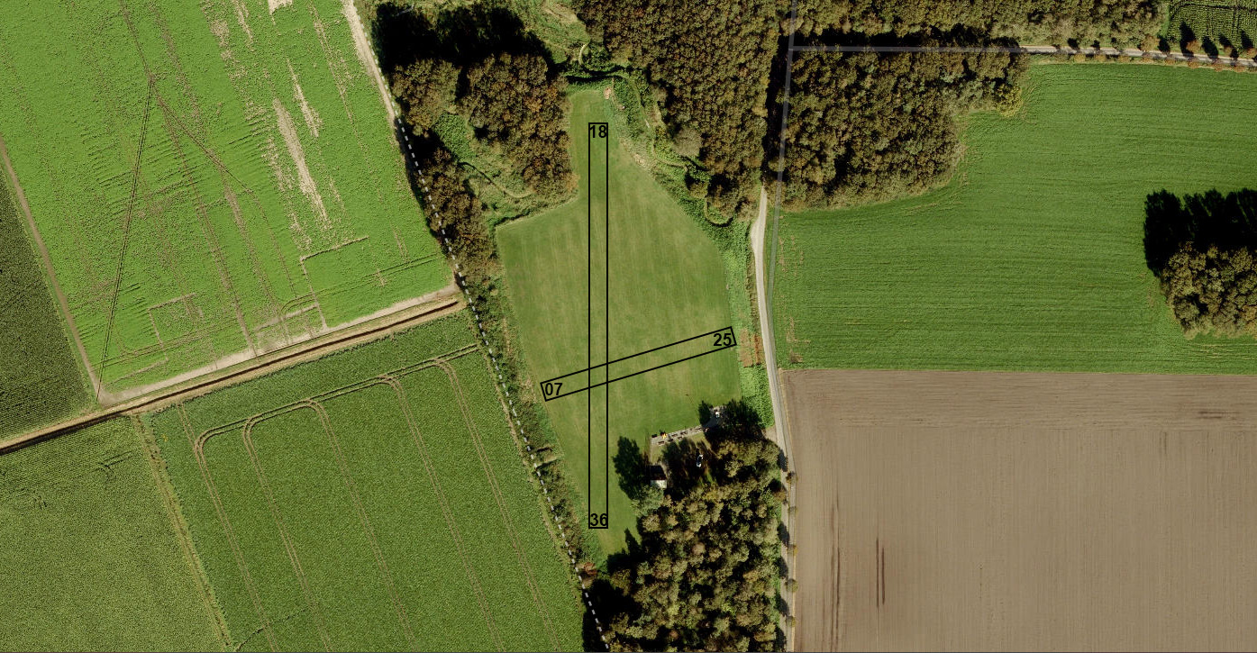
Runways

RWY Hdg° Xw Bf Xw m/s Head Bf m/s
07 70 1 1.2 4 7.5 tail
25 250 1 1.2 4 7.5
36 360 4 6.7 3 3.7 tail
18 180 4 6.7 3 3.7

Cross / head as scalars; sign of headwind component: tail labelled.

Sources

GFS: OK
ICON: OK
ECMWF: OK
ARPEGE: OK
KNMI HARMONIE: OK
MET Norway: OK
DWD (Bright Sky): OK

Model merge generated Sun 25 Oct 2026 09:05 · Weather APIs run on the server about once every hour — not when you load this page.

Hourly — 48 h

Time Rain% W Bf W m/s G Bf G m/s °C Td °C ° ±° Xw Bf Xw m/s
Sun 25 Oct 2026 09:00 5 4 7.6 6 11.1 11.3 6.5 241 27 4 6.7
Sun 25 Oct 2026 10:00 10 5 7.9 6 11.7 12 6.3 247 24 4 7.3
Sun 25 Oct 2026 11:00 29 5 8.6 6 12.5 12.3 6.1 253 27 5 8.3
Sun 25 Oct 2026 12:00 47 5 9.2 6 13.2 12.5 5.8 259 26 5 9
Sun 25 Oct 2026 13:00 61 5 9.3 6 13.4 12.2 5.7 260 24 5 9.1
Sun 25 Oct 2026 14:00 64 5 8.8 6 13.1 11.8 5.7 261 22 5 8.7
Sun 25 Oct 2026 15:00 60 5 8.6 6 12.4 11.4 5.5 260 24 5 8.5
Sun 25 Oct 2026 16:00 55 5 8.3 6 12 11 5.1 257 23 5 8.1
Sun 25 Oct 2026 17:00 44 4 7.5 6 11.5 10.2 4.4 257 24 4 7.3
Sun 25 Oct 2026 18:00 34 4 6.7 5 9.9 9.3 4.5 250 30 4 6.3
Sun 25 Oct 2026 19:00 29 4 6.4 5 9.4 9.2 4.4 244 35 4 5.8
Sun 25 Oct 2026 20:00 22 4 6.4 5 9.2 9.1 4.1 242 34 4 5.7
Sun 25 Oct 2026 21:00 17 4 6.5 5 9.4 9 4.2 242 32 4 5.7
Sun 25 Oct 2026 22:00 12 4 6.3 5 9.1 8.9 4.4 241 30 4 5.5
Sun 25 Oct 2026 23:00 7 4 6 5 8.9 8.6 4.4 238 18.3 3 5.1
Mon 26 Oct 2026 00:00 7 4 5.9 5 8.5 8.4 4.4 236 20 3 4.9
Mon 26 Oct 2026 01:00 3 4 5.7 5 8.3 8.3 4.5 234 19.8 3 4.6
Mon 26 Oct 2026 02:00 2 4 5.5 4 7.9 8.1 4.5 230 23 3 4.2
Mon 26 Oct 2026 03:00 1 4 5.6 5 7.9 7.8 4.5 226 29.9 3 4.1
Mon 26 Oct 2026 04:00 1 3 5.4 4 7.8 7.6 4.6 224 20 3 3.8
Mon 26 Oct 2026 05:00 1 3 5.2 4 7.4 7.3 4.7 220 14 3 3.3
Mon 26 Oct 2026 06:00 1 3 4.9 4 7.3 7.2 5 216 14 2 2.8
Mon 26 Oct 2026 07:00 1 3 4.8 4 7.1 7.4 5.4 213 9 2 2.9
Mon 26 Oct 2026 08:00 1 3 4.9 4 7 8.5 6.2 212 7.9 2 3
Mon 26 Oct 2026 09:00 1 3 5.1 4 7.2 9.6 6.8 211 10.6 2 3.2
Mon 26 Oct 2026 10:00 1 3 5 4 7.3 10.3 7.1 208 9 3 3.4
Mon 26 Oct 2026 11:00 0 3 5.1 4 7.3 10.8 7.1 203 10 3 3.7
Mon 26 Oct 2026 12:00 0 3 5.2 4 7.3 11.8 7.1 202 24 3 3.9
Mon 26 Oct 2026 13:00 1 4 5.4 4 7.6 12.3 6.9 200 16 3 4.1
Mon 26 Oct 2026 14:00 9 4 5.6 4 7.8 12.1 6.8 198 17 3 4.4
Mon 26 Oct 2026 15:00 23 4 5.6 5 8 11.5 7 193 15.7 3 4.7
Mon 26 Oct 2026 16:00 41 4 5.7 5 8.1 10.8 7.7 186 12.4 3 5.1
Mon 26 Oct 2026 17:00 51 4 5.9 5 8.5 10.4 7.9 186 10 3 5.3
Mon 26 Oct 2026 18:00 41 4 6.3 5 8.9 10.4 8.2 189 13 4 5.5
Mon 26 Oct 2026 19:00 33 4 6.2 5 9.1 10.6 8.5 193 15 3 5.2
Mon 26 Oct 2026 20:00 27 4 6.3 5 9.1 10.9 8.9 197 15 3 5
Mon 26 Oct 2026 21:00 16 4 6.2 5 8.9 11.2 9.3 198 14 3 4.8
Mon 26 Oct 2026 22:00 11 4 5.9 5 8.6 11.4 9.6 198 13 3 4.6
Mon 26 Oct 2026 23:00 7 4 5.8 5 8.2 11.7 9.9 198 18 3 4.5
Tue 27 Oct 2026 00:00 1 4 5.5 5 8.1 11.9 10.2 197 12 3 4.4
Tue 27 Oct 2026 01:00 2 4 5.5 5 7.9 12.1 10.5 195 13 3 4.5
Tue 27 Oct 2026 02:00 1 4 5.5 5 8 12.3 10.7 195 12 3 4.5
Tue 27 Oct 2026 03:00 2 4 5.4 5 8.1 12.2 10.9 194 12 3 4.5
Tue 27 Oct 2026 04:00 2 4 5.5 5 8.2 12.3 11 191 14 3 4.7
Tue 27 Oct 2026 05:00 1 4 5.7 5 8.5 12.4 11.1 191 18 3 4.9
Tue 27 Oct 2026 06:00 1 4 5.8 5 8.8 12.6 11.2 191 16 3 5
Tue 27 Oct 2026 07:00 1 4 5.7 5 8.6 12.7 11.2 190 15.3 3 4.9
Tue 27 Oct 2026 08:00 1 4 5.9 5 8.6 13.2 11.3 190 14.8 3 5.1
Tue 27 Oct 2026 09:00 1 4 5.8 5 8.7 13.9 11.6 191 15 3 5

About these columns

Each row is one forecast hour (multi-model blend from Sources). Times are Europe/Amsterdam; the row label is the start of that hour.

  • Time — start of the hour bucket (Europe/Amsterdam).
  • Rain % — precipitation probability (0–100) from blended models.
  • W Bf / W m/s — sustained wind at ~10 m: Beaufort class and metres per second.
  • G Bf / G m/s — gusts at the same level; missing gusts are interpolated from sustained wind.
  • °C — air temperature consensus.
  • Td °C — dew point (moisture) for that same hour.
  • ° — mean wind direction in degrees true; wind blows from that bearing toward the circle centre on the map.
  • ±° — directional spread among models (scatter of headings). Larger means less agreement.
  • Xw Bf / Xw m/s — strongest crosswind along any club runway heading in the runway table.